Tropical Storm Fred Expected To Make Landfall At Florida Panhandle
Aug 16, 2021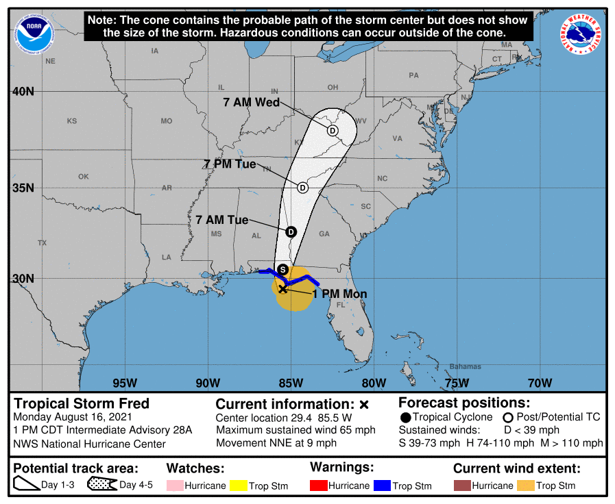
Tropical Storm Fred is predicted to make landfall at the western portion of the Florida Panhandle Monday afternoon or evening. A tropical storm warning is in effect for a large section of the Panhandle as Fred approaches with tropical storm force winds, heavy rain and storm surge.
Fred had weakened to a depression after it traveled through Haiti and the Dominican Republic where it knocked out power to about 400,000 customers and caused flooding that forced authorities to shutter part of the country’s aqueduct system, interrupting water service for hundreds of thousands of people. It was expected to regain tropical storm strength as it approached Florida.
Florida Governor Ron DeSantis warned via tweet on Friday that Floridians should expect heavy rainfall through the weekend and into Monday.
It is expected that the heaviest rainfall will be from the Florida Big Bend Coast to the panhandle with 4-inches to 8-inches of rain. Storm totals are forecasted to be 12-inches.
The worst of the storm surge will hit along the coast near the eventual landfall location.
Once onshore, the storm is expected to weaken quickly. Still, high rainfall totals are expected as it passes through Florida into Alabama and Georgia. Rainfall totals are expected to be from 4-7-inches and about 10-inches in isolated areas through Tuesday.
Meanwhile, Tropical Depression Grace is bearing down on Haiti and should make landfall there on Monday night and Tuesday morning. Rain totals could be as much as 5-10-inches. Mudslides are predicted as a result of heavy rain and damage from an earthquake. It is then expected to go on to Jamaica on Tuesday.
The tropical depression will then continue west toward the Gulf of Mexico and the Yucatan Peninsula by the end of the week.
The flash flood threat coming from Fred could stretch from Atlanta to Richmond, Virginia and Washington, D.C. by Wednesday.
In addition, a new tropical depression is forming near Bermuda Monday morning that could become Tropical Storm Henri later in the day.
Grace formed Saturday morning, August 14th in the Atlantic Ocean grew stronger while Fred weakened into a tropical wave as it moved into the eastern Gulf of Mexico.
A tropical storm warning was announced for the British Virgin Islands, the U.S. Virgin Islands, and Puerto Rico. A tropical storm watch was in effect in the Dominican Republic.
As of 2:20 p.m. east coast time on Monday, powerOutage.us reported that top areas of blackouts included:
- Puerto Rico 16,466
- Florida 4,595
Due to wildfires in California, more than 17,200 customers were without power and because of heavy rains and flooding that hit Michigan on Thursday, August 12th, more than 119,700 electric customers were still without power on Monday.
With multiple tropical storms and depressions form in the Atlantic during another hurricane season, it could be likely that the southern region of the U.S. could be hit with storms right after the other. It wouldn’t be surprising if this scenario led to a hurricane that would arrive while the region is still suffering through blackouts.
Owning a standby backup generator from APElectric could provide power in your home if electric utility blackouts continue on for days. The company is offering a wide range of generators that are manufactured by some of the most popular brands in the U.S. including Cummins, Westinghouse, Kohler, Briggs & Stratton, Generac, Firman, and Guardian. They have a large inventory to choose from. Many models feature Wi-Fi so that you can monitor and control the generator from anywhere on Earth. Their website also includes a generator sizing calculator and offers information on how to select the proper generator for your situation.
As storms get stronger and more frequent due to global warming, it’s best to be prepared. Visit the APElectric website and browse their supply of generators. Purchasing one can give you peace of mind during these crazy storm seasons.