Isaias Makes Landfall In North Carolina
Aug 04, 2020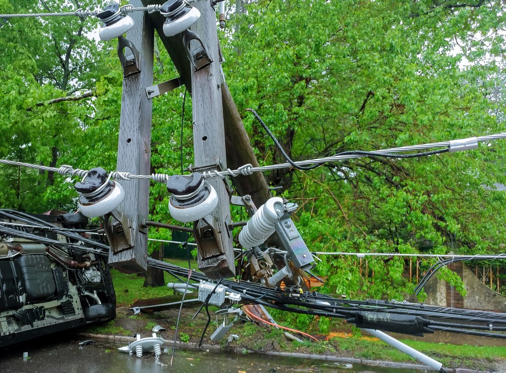
Isaias made landfall near Ocean Isle Beach, North Carolina a little after 11 p.m. Monday, August 3 as a Category 1 hurricane. At the time, its maximum sustained winds were 85-mph.
As the storm approached the shore, a gauge on a pier in Myrtle Beach recorded the third highest water level since the gauge had been set up in 1976. Only Hurricane Hugo in 1989 and Hurricane Matthew in 2016 pushed more ocean water inland.
The U.S. National Hurricane Center cautioned residents near the beach to expect a storm surge of up to 5-feet and about 8-inches of rain as the hurricane makes its way north through the state.
Oceanfront streets in the area of landfall flooded as seawater ended up about 10 feet above low tide.
A spokesman with the U.S. National Hurricane Center warned that the heavy rains could result in flash floods in sections of eastern Carolinas and mid-Atlantic. It is expected to hug along the coast as it heads north toward the New England states.
A tropical storm warning is in effect along the northeast up to Maine where flash flooding could occur on Tuesday, August 4.
There were also warnings of possible tornadoes in North Carolina on Monday night and early Tuesday. Tornadoes could strike eastern Virginia through southern New England later on Tuesday.
The storm remained at sea after skirting the east coast of Florida over the weekend. Florida residents wearing masks to protect themselves of the Coronavirus were already massing in storm shelters.
In southern North Carolina, high winds from the hurricane knocked down trees and power lines. The Hurricane Center was forecasting storm surges of 3 to 5-feet for North Carolina as Isaias moved onshore.
The Hurricane Center predicted that winds from the hurricane could be “significant.” Accompanying the winds will be tropical-storm-force-winds, especially in coastal areas. It is also expected that the storm will cause a storm surge of 1 to 3 feet above normally dry land along the coast from the Virginia Tidewater to southern New England.
As of Tuesday morning, August 4, the latest information claimed that:
- The storm was centered 45 miles south-southeast of Annapolis, MD at 10 a.m. Maximum sustained winds were 70-mph. The storm was traveling north-northeast at 20-mph.
- Rainfall of 3-to-6-inches is forecasted for the Mid-Atlantic with heavy rain occurring along the I-95 corridor. Rainfall should decrease to 2-to-4-inches from eastern New York into Vermont. New England is expected to get rainfall in the range of 1-to-3-inches.
- A tornado watch had been issued for much of the Delmarva (Delaware-Maryland-Virginia) Peninsula, southern New Jersey, eastern Maryland and a small section of eastern Virginia until about 12 p.m. on Tuesday. A second tornado watch was issued for eastern Pennsylvania, central and northern New Jersey, southern New York state, and southern Connecticut until 4 p.m.
At around 9:30 Tuesday heavy rain and flooding was reported in Washington, D.C. Flood and flash flood warnings were in effect for much of D.C.
The most extreme rain was in the far southeastern suburbs of Washington in Southern Maryland where there was as much as 6 to 7-inches of rain, which resulted in considerable flooding. A stream in St. Mary’s County Maryland rose to its highest level since Hurricane Irene dumped rain there in 2011.
At about 8:30 a.m. on Tuesday, it was reported that 300,000 residents in Virginia had lost power. As many as 641,000 utility customers were without power, mostly in North Carolina and Virginia.
Dominion Energy said that nearly 900 of its customers were without power in Northern Virginia, near Washington.
Southern Maryland Electric Cooperative reported that about 5,000 of its customers were without power in Southern Maryland. Pepco claimed that about 200 of its customers were without power in Washington, D.C., and Montgomery and Prince George’s counties. Conditions deteriorated near Washington as the storm moved north at about 33-mph Tuesday morning.
Significant flash flooding was also predicted for Baltimore and Philadelphia.
Peak Power Outages By County and State
| County | State | DMA | Peak Outage Count |
| New Hanover County | NC | Wilmington, NC | 92,710 |
| Brunswick County | NC | Wilmington, NC | 51,353 |
| Onslow County | NC | Greenville-New Bern-Washington, NC | 44,868 |
| Pender County | NC | Wilmington, NC | 28,765 |
| Craven County | NC | Greenville-New Bern-Washington, NC | 23,245 |
| Carteret County | NC | Greenville-New Bern-Washington, NC | 11,671 |
| Wake County | NC | Raleigh-Durham (Fayetteville), NC | 10,038 |
| Virginia Beach County | VA | Norfolk-Portsmouth-Newport News, VA | 74,009 |
| Chesapeake County | VA | Norfolk-Portsmouth-Newport News, VA | 54,387 |
| Newport News County | VA | Norfolk-Portsmouth-Newport News, VA | 32,147 |
| Norfolk County | VA | Norfolk-Portsmouth-Newport News, VA | 30,268 |
| Suffolk County | VA | Norfolk-Portsmouth-Newport News, VA | 23,591 |
| Hampton County | VA | Norfolk-Portsmouth-Newport News, VA | 18,309 |
| Portsmouth County | VA | Norfolk-Portsmouth-Newport News, VA | 14,361 |
Whether it’s due to global warming or some other weather phenomenon, the 2020 hurricane season started early. It is the first time on record that two hurricanes had been generated in the Atlantic in the last week of July.
With hurricanes becoming more widespread, the need for protection against power outages becomes that much more important.
APElectric offers a wide range of stand-alone generators from such manufacturers as Cummins, Westinghouse, Kohler, Briggs & Stratton, Generac, Firman, and Guardian. They have a large inventory to choose from. Many models feature Wi-Fi so that you can monitor and control the generator from anywhere on Earth. Their website also includes a generator sizing calculator and offers information on how to select the proper generator for your situation.
As storms get stronger, it’s best to be prepared. Visit the APElectric website and browse their supply of generators. Purchasing one can give you peace of mind during these crazy storm seasons.