Residents Of West Coast Brace For Series Of Severe Storms
Oct 22, 2021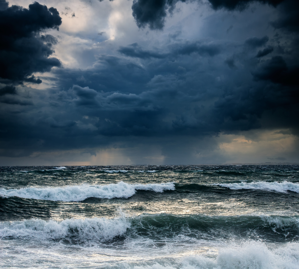
A train storm consisting of a bomb cyclone and two other severe weather occurrences is expected to hit the west coast of the United States this weekend and into next week (Friday, October 22 through Tuesday, October 26).
The bomb cyclone developed over the northern Pacific Wednesday night and on into Thursday morning. It is this storm that is expected to be the catalyst that marshals in a series of storms. The weather phenomenon is expected to dump as much as 2-feet of rain in some areas and up to several feet of snow over the mountains. The precipitation is a Godsend as far as the wildfires that have been plaguing the region and could help a drought situation that has devastated a number of states. However, the event could cause major flooding, mudslides, and significant threat to lives and property.
According to the National Weather Service a bomb cyclone, also known as a bombogenesis, occurs when a mid-latitude cyclone becomes more intense very fast, generally within a period of 24-hours. The intensity of the storm builds because of a rapid dropping of the atmospheric pressure. The drop of pressure causes cold and warm air to collide over warm ocean water. The quick rotating winds around the low-pressure area create the cyclone.
A number of different weather events can occur as a result of a mid-latitude bomb cyclone including storms and heavy rain as well as heavy winds.
The weather could cause additional major problems because the area that is being affected has been damaged by widespread wildfires. The fires have caused scars in the ground, making it susceptible to flash flooding and debris flows.
The Western and Central Wyoming Weather Forecast Office explained that the debris flows would mostly affect downhill areas as the heavy rain causes major erosion because of the unstable ground. Ash, silt and burned vegetation flows downhill resulting in a lot of damage.
In addition, ground fires cause hardened layers that form over the topsoil preventing the rain from being absorbed. So, flooding occurs almost instantly upon the rainwater hitting the ground.
The storm appears similar to a hurricane in images taken when it was off the coast of western Canada and the U.S. Northwest on Thursday. The storm’s central atmospheric pressure plunged from 986 millibars to 953 millibars. That’s 29.12-inches of mercury down to 28.14 inches of mercury, which meets the official criteria of a bombogenesis.
According to weather authorities in Canada, the storm’s wind gust has been measured at up to 100 mph and it was causing 31-feet waves off the shore of Vancouver Island.
Three storms, led by the cyclone, have lined up over the northern Pacific Ocean and are heading for the western U.S. Each storm will bring its own varying degree of power and effect. The combined effects of the three storms are expected to be striking.
The areas expected to get the worst of it include the coast of British Columbia, which will experience heavy rains and strong winds. Heavy rain, gusty winds and punishing surf will strike Washington, Oregon, and Northern California.
Later a weaker storm will follow through into Washington, Oregon and Northern California on Saturday. The third storm in the series may experience rapid intensification and could become another bomb cyclone. This storm is expected to form farther south resulting in heavy precipitation and strong winds along the West Coast and pull in deep tropical moisture from the Pacific Ocean that will create what is called an “atmospheric river.” Similar to a firehouse of moisture in the sky, this phenomenon could offer severe rain and snow in the mountains. The target of the “atmospheric river” is expected to be in the northern and central regions of California and sections of southern Oregon. The worst of it is expected for Sunday morning through Monday. Rain of more than 1 to 2-inches an hour for several hours is expected and could lead to rapid runoff over steep terrain facing the ocean.
AccuWeather forecasts a total of 4 to 8 inches of rain in Northern and Central California and a total of 16-inches from Sunday to Tuesday. This storm will affect San Francisco and Sacramento where urban flooding is said to be a certainty.
The second bomb cyclone, which may be stronger than the first, will pummel the coast of Northern California and southern Oregon from Sunday to Monday. Wind gusts are predicted to average 40 to 60 mph. This will cause trees to fall as well as property damage and could also result in sporadic to regional power outages.
How far south the storm goes depends on the location of the jet stream, which will be shifting farther south. So rainfall could extend to Southern California early next week, which will affect Los Angeles and San Diego.
In addition, snow is expected to fall at elevations above 8,000 feet on Sunday through Tuesday, with the majority of snowfall over the Sierra Nevada. AccuWeather forecasters predict from 60 to 100-inches of snow above 8,000 feet.
The precipitation is expected to douse the wildfires in Northern California, but won’t affect the multi-year drought that has plagued the state. California Governor Gavin Newsom declared a drought emergency for the entire state.
Severe weather occurrences can happen at any time, anywhere in the country. Being prepared for blackouts that could result is becoming more and more essential. Visit the APElectric website to review their inventory of standalone generators from some of the most popular manufacturers in the trade. These machines have the ability to seamlessly transition your home from a blackout to restored energy almost immediately.
The staff is available to answer questions you have concerning how to select the right generator for your particular situation and will detail the various features of each generator that peaks your interest.